Montana Solo Cross-Country
By Brian Carroll1
Editor’s Note: There are some great milestones in learning to fly. Every pilot remembers first solo – when the instructor, after a few good landings, tells you to stop on the ramp, signs your student pilot certificate and logbook, tells you to take two or three trips around the traffic pattern, and steps out of the aircraft. But for many, the true highlights are the solo cross countries, when we take wing (with instructor approval of course) for a flight more than 50 nautical miles away from home. This is the story of one of those flights – the so-called “long” cross country – a round trip of a minimum of 150 nautical miles with landings at at least three 3 airports.
It’s May 28, 2005. I wake up early today, about 5 AM. I didn’t sleep very well worrying about the weather. All was for naught, as it is a beautiful morning. The official Terminal Area Forecasts (TAF) and current condition reports (METAR) agree in calling for clear skies and calm winds. I have been fighting weather and work for a few weeks now, trying to complete my solo long cross country.
The plan is for a morning round trip flight from my home base at Helena, Montana (KHLN) with stops at Dillon (KDLN), Bozeman (KBZN) and Townsend (8U8) to visit family before returning to base. After a lengthy preflight of N7221Q, I depart Helena at 7:20 AM and pick up the VOR navigational signal for a southern departure, climbing to 9,500 feet. Everything is clicking perfectly.
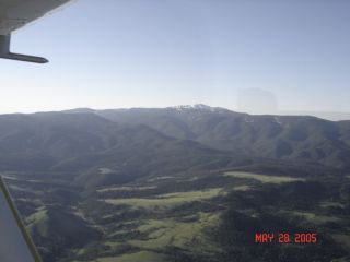
I reach my first visual checkpoint, the town of Clancy, right on the money. Five minutes later, I get a beautiful view of Elkhorn Peak to my left. Today I am much calmer and more collected than my first solo cross country; I must becoming a real pilot. What a feeling! A short time later, I’m looking down at Whitehall and Jeffco Skypark(nice little grass strip). Twin Bridges and the Beaverhead River pass underneath, the sun bouncing off the winding river is amazing.
I arrive at Dillon (KDLN) right on schedule. I make all my radio calls in the traffic pattern, but my turn to base and to final are a little tight and I end up a bit high. It’s my first time here and Dillon’s Runway 21 is shorter and narrower than the runway I’m used to back home. So I decide to exercise my privileges as pilot-in-command, go-around and set up for another try. Next time around as I turn to the base leg of the pattern, another airplane announces that he is going to “back-taxi” on the runway (opposite my landing direction) in preparation for takeoff. A quick call to announce my location again, and the other pilot says he had just turned on his radio, missed my last position report, and will wait. Whew! A successful landing and a short pit stop at Dillon, and I’m off to the northeast towards Bozeman.
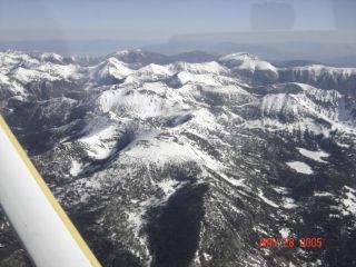
I begin my climb to 12,500 feet to clear the 10,500 foot Tobacco Root Mountains. I discussed this departure with my instructor the day before the trip. He told me that if there were no mountain cloud coverage, I should keep climbing until I am at the ridge line. I 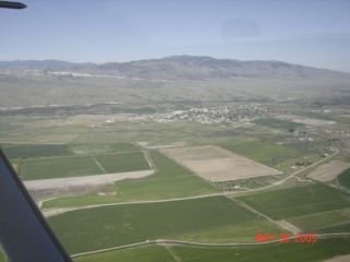 haven’t crossed from one valley to another over a major mountain range before. I’ve usually used lower passes and, even then, had an instructor with me. So I am naturally a bit nervous. Climb is perfect and I am at 12,500 feet by the time I get to the ridge. The view is freakin’ awesome, although it does puts a whole new spin on thought of what to do if my engine quits! As I descend on the other side towards Bozeman, I notice my GPS telling me that my groundspeed is 110 knots (about 125 MPH). Not bad for 2400 RPM in a little Cessna 172 with 11,000 flight hours on it. Of course I am going downhill!
There is lots traffic at Bozeman (KBZN). As instructed by the Air Traffic Control Tower, I report midfield right downwind for Runway 12. The Tower informs me I’m Number 2 for landing, after another aircraft that is turning left base. A moment later, I told I’m Number 1, cleared for “the option” (my choice, including landing, doing a “touch and go,” or stopping on the runway and taking off again). I’m also told to “keep it tight.” Okay. I’ve never been asked to “keep it tight” before but I do my best. I come in a little fast, float down the runway a bit, but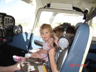
hold the runway centerline well, so I’m happy with my performance. I tell ATC that I want a departure to the north and I’m on my way again. I’m glad to be clear of all that Bozeman traffic as I climb to 6,500 feet.
I stay low to fly over the Toston Dam (where I work), and rock the wings as I pass over as a greeting to unseen friends. I glance at my watch; it’s 9:30 AM. Darn! I told my daughter I would be at Townsend at 9:30 and my time estimates didn’t account enough for the go-around at Dillon and the traffic at Bozeman. But only eight minutes later I am flying over Townsend (8U8) to check the windsock. It looks like there’s a light wind favoring Runway 34. On downwind, I glance at the empty parking lot. After turning final, I can see a truck zooming down Airport Road. Could it be them? But no time to think about anything other than flying the airplane and landing. Just 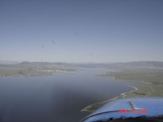 before touchdown though (a very nice one, thank you), I can’t resist a peek and see my daughter jumping out of her truck. As I back-taxi to parking, I see my 5 year old grandson hanging on the fence. I shut down and call him over, I don’t know who is more excited, he or I.
After a nice visit with the kids, I blast off from Townsend for the trip home, I fly the East shore of our local lake and have a view of lots of walleye fisherman complete with a float plane. Back home at Helena, I kind of let my guard down and the crosswind for my landing gets the better of me (a little bit anyway). But overall, it has been a gorgeous and successful day for a new pilot. The last of the formal requirements complete, I know my check ride for my private pilot certificate is not far away!
1. Story and photographs copyright ©2005 Brian Carroll. All Rights Reserved. Return to story.