Santa Monica to Catalina Island
Braving the Dreaded SOCAL Airspace
As many pilots who live and fly outside California, I’ve been apprehensive about flying in the complex airspace in the Los Angeles area. The Los Angeles terminal area is a noticeably non-“wedding cake” Class B.A specific FAR requirement for pilots to carry a current VFR Terminal Area Chart (SFAR No. 51-1). Class C abutting or underlying Class B. A multitude of towered Class D and non-towered airports within and under. VFR corridors, some requiring clearances, some not. I had also learned that aircraft rental operators in the are do not permit renters to fly to Catalina Island, a beautiful island about 20 NM off coast, without a “Catalina checkout” — much as Colorado operators wisely require a “mountain checkout” before affording their renters the privileges of flying in the Rocky Mountain splendor.
So when I registered for a professional conference in Los Angeles, I saw it as a dual opportunity — find a friendly operator with a knowledgeable CFI and take the plunge.
 My planned trip took me close to Santa Monica Airport ((SMO)). Perfect! A flight from Santa Monica to Catalina ((AVX)) would involve crossing the heart of the Los Angeles Class B airspace. My search on AirNav for a suitable operator uncovered a number of flight schools that rented aircraft, including Proteus Air Services, a small but very professionally run flight school located on the “south field” of the airport. A few emails back and forth and my conference schedule included a mid-afternoon flight to Catalina. (Unfortunately, a mid-afternoon flight would not permit a tour of the island itself. Fortunately, the “checkout” would allow me to fly there solo on my next trip and spend the day.)
As CFIs and pilots all know, the cockpit is very bad classroom, so my preflight briefing with Nick Burik, an excellent young CFI, began with and examination of the Los Angeles Terminal Area Chart and a discussion of our route of flight, the airspace we would deal with, and the procedures we would follow.
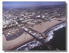
SMO is a towered airport with Class D airspace rising from the surface to 2400 feet. It’s runway is also only 5 NM from the center of the Los Angeles International Airport’s ((LAX)) 4-runway complex. Although Class B begins at 5000 feet directly over and to the northwest of SMO, it drops to the surface only 3 NM to the southeast, about 1/2 mile from the nearest LAX runway.
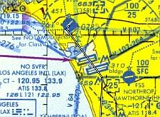
Fortunately, the Los Angeles Class B configuration does an admirable job of accommodating VFR general aviation. A “Special Flight Rules Area” corridor , about 5 NM wide along the SMO VOR’s 132° radial, runs directly over the LAX runway complex. VFR aircraft traveling through the corridor fly a “hard altitude” of 3500 feet southeast bound and 4500 northwestbound. Contact with Air Traffic Control is neither required nor wanted. Instead, aircraft negotiating the corridor squawk 1201 on their transponders to identify themselves on ATC radar and make position reports to other aircraft on 128.55 to alert other aircraft as an adjunct to their see-and-avoid responsibilities. (The rules are contained in SFAR No. 51-1 and are depicted on the LAX Terminal Area Chart)
 Preflight briefing and a preflight of our Cherokee 180 complete, we were ready to go.
Our takeoff clearance on SMO’s runway 21 included approval of our request for a “climbing right 270 to enter the corridor.” (Santa Monica noise abatement procedures at SMO make this more of a rectangle than a circle, a good thing since we needed to climb from SMO’s 175 foot elevation to 3500 feet before recrossing the airfield.) A northerly turn up the coast and another back to the departure end of the runway, and we were on our way.
Dial in 1201 on our transponder, 128.55 on our communication radio, and key the mike.
“Corridor traffic. Cherokee 400JW. Over Santa Monica. Entering the corridor at three thousand five hundred.” Although the SMO 132° radial is our navigational guide, the corridor is not that tight. In fact, the VOR is barely even necessary for the initiated. The SMO VOR is right at the departure end of runway of runway 21. With LAX so close, just fly directly over the numbers of Santa Monica’s runway 3 and point the nose at the center of LAX, and you will be right on the proper track.
Position reports “over Ballona Creek”, “over LAX” (where we watched a large jet land directly below us) and “exiting the corridor”, and a few short minutes later we were clear. Continuing along the shore at 3500 feet toward Palos Verde Point kept us comfortable clear of Class B. By this time, we could see the peaks of Catalina Island 20 NM directly in front of us.
 Well before you make your first call to Catalina Unicom to advise them of your intentions to land at the “Airport in the sky”, you appreciate the wisdom of the operators’ “Catalina checkout” requirement.
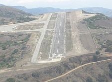
The airport (AVX) sits 1600 feet above sea level on Santa Catalina Island which rises from the sea to almost 2200 feet. It’s 3000′ runway slopes almost 2° from end to end and, although paved, is uneven with soft spots and a few potholes for the unwary. On a man-made plateau apparently cut out of the side of the mountain, both ends of the runway end with sheer vertical drop-offs. Landing too short, instead of a landing in the dirt, means nosing into the side of the mountain. Too long is likely to ruin your day as well. Like other plateau airports, AVX is subject to downdrafts on the final approach course. The need for close attention to airspeed and altitude and attention to the visual illusions produced by sloping runways are a must and a test of piloting skills. Adjusting our airspeed for the 8-knot gust factor and moving our ailerons and rudder to control our path for a moderate but gusting crosswind, we made an uneventful landing on runway 22.
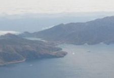 The airport is run by the Catalina Island Conservancy, so the landing fee goes to a good purpose. After a brief stopover for a cup of coffee at Buffalo Springs Station (our visit was brief; the airport closes at 5 PM), we climbed back into our Cherokee for the return flight. The windy takeoff on runway 22 was uneventful and our wide right downwind departure between the two peaks on either side of the isthmus gave us an incredible view of beautifulTwo Harbors. Climb to 4500, point our selves back toward Palos Verde, and we were ready to intercept the SMO 132° Radial for our trip back though the Special Flight Rules corridor back to Santa Monica. Cleared to land via a descending right downwind to SMO’s runway 21, and we were back home.
Every area has it’s own beauty. For many of us, who usually fly light airplanes within 1-3 hours of our home bases, flying somewhere new can also be educational. For me, used to flying the dry flat plains and majestic mountains of Colorado, flying the beautiful southern California coastal area and the infamous SOCAL airspace was a real treat!
Santa Monica aerial photo courtesy of Richard Eller. ©2000 Aerial Images. All Rights Reserved. Interested in aerial photography? Photographer Richard Eller is also the author of The Secrets of Successful Aerial Photography available at www.aerialimages.com/purchase/books/books.html
Catalina Island photos courtesy of and ©2002 John Heldt. All Rights Reserved.